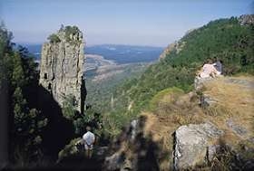
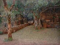
 The Pinnacle Rock
The Pinnacle Rock, a tower-like
freestanding quartzite buttress which rises 30 m above the dense indigenous
forest, is 6 km north of Graskop on the R534 road (a scenic loop off the
R532 road). To the right of the Pinnacle Rock is the first of eight small
waterfalls in the Ngwaritsane stream.
|
|
God's Window & Wonder
View
God's Window - so called for the panoramic view
of the Lowveld (and in the distance the Kruger National Park and Mozambique)
more than 900 m below - is 9.2 km north of Graskop on the R534 road.
From the parking area a steep footpath along the edge of the escarpment
leads to the actual view site where there is a Wild Nature Reserve.
Wonder View is about 2 km north of God's Window. At an altitude of
1,730 m this is the highest viewpoint in the area. No walking
necessary as the viewpoint is right next to the road.
Choose a clear day to best enjoy
the views from both God's Window and Wonder View.
|

|
Lisbon Falls
Where the R534 rejoins the R532 road, you turn
left (back towards Graskop) for 800 m and then right onto a gravel
road. The falls is a further 2.2 km. At 92 m the
Lisbon Falls is the highest waterfall in the area.
There is no entry fee to visit this
waterfall.
|

|
Berlin Falls
From Lisbon Falls you drive back to the tar road
(R532) and turn left (north). Drive for 2 km (past the R534 turnoff) and
then turn off left. Drive past the Berlin Sawmill and at 2 km from the
main road, turn left and park at the parking area.  A short walk takes you to
a vantage point overlooking the 45 m high Berlin Falls. A short walk takes you to
a vantage point overlooking the 45 m high Berlin Falls.
There is no entry fee to visit this
waterfall.
|
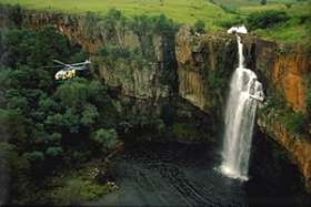
Photo: SA Tourism
|
Bourke's Luck Potholes
This natural water feature marks the beginning
of the Blyde River Canyon. Through countless eons the swirling
whirlpools which occur as the Treur River plunges into the Blyde River
caused waterborne sand and rock to grind huge, cylindrical potholes into the
bedrock of the river.
The Potholes were named after a gold digger,
Tom Burke, who staked a claim nearby. Although his claim did not
produce a single ounce of gold, he correctly predicted that large gold
deposits would be found in the area.
The Potholes is located 35km north of Graskop town on the R532 road. The
informative visitors centre details some of the interesting natural and
socio-historic features and is the starting point of the 700m walk to the
potholes.
Entry Fees: (valid until October 2009)
R25/adult
R15/kid under 12 years
R10/learner (group bookings in advance)
Plus:
R5/car, R30/combi,
R50/bus
Contact: 073 774-3617
|
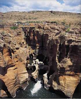
Photo: SA Tourism
|
Lowveld View
This viewpoint, between Bourke's Luck
Potholes and the Three Rondawels on the R532, offers stunning views of
the Blyde River Canyon, the Blyde Dam and the Lowveld beyond.
|

Photo: SA Tourism
|
Three Rondawels
Further north along the R532 road, the turnoff
to the Three Rondawels viewpoint is 4.6 km from the Lowveld View
turnoff (41 km from Graskop) and the parking area another 2.8 km
further. The word "Rondawel" is a South African word that
refers to a round hut-like dwelling (usually with a thatched roof).
The three well known gigantic peaks of quartzite and shale with their sheer
rock walls tower more than 700 m above the surrounding landscape.
These peaks are named after the three most troublesome wives of Chief Maripi
Mashile - they are
(from left to right) Magabolle, Mogoladikwe and Maseroto.
|

Photo: SA Tourism
|
Blyde River Canyon
One of the best viewpoints of the Blyde River
Canyon is from the parking lot behind the chalets at the Aventura Blydepoort
Nature Reserve Resort, 51 km north of Graskop on the R532 road.
The 25 km long Blyde River Canyon is the third
largest canyon in the world and was formed by rivers cutting deep into the
escarpment and eroding millions of tons of rock which were carried to the
Lowveld and beyond to the Indian Ocean. More than 700 m below the
370 ha Blyde River Dam is visible towards the lower end of the canyon
at the confluence of the Blyde and Ohrigstad Rivers.
|
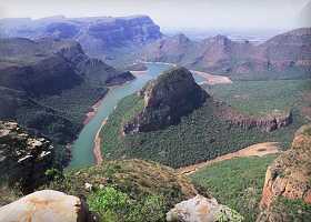
Photo: Chris du Plessis
|
Echo Caves
The Echo Caves, located 15km west of the Strydom Tunnel in the Molopong
Valley, have sheltered humans since the Middle Stone Age, and continue to
protect some of the region's most inspiring ancient San rock engravings. The
caves, which boast a chamber 100m long and 40m high, also have dripstone
formations that echo eerily when struck. The 2km guided tour lasts
45min.
Entrance fee:
R30
for adults and R15 for children under 12.
Times:
08:30 - 16:30.
|

|
Reptile Park
In
1984 the Swadini Reptile Park was founded and developed by Donald Strydom a
pioneer in the care and rehabilitation of "problem reptiles" in
the Hoedspruit region. The Swadini Retile Park is now a renowned South
African landmark and Strydom has had his work featured on international
television networks such as The National Geographic Channel and The
Discovery Channel.
The Swadini Reptile Park has been collecting
data from animals caught in the wild for the past 16 years and has been
inspired to initiate a number of research projects through HERP (Help
Endangered Reptile Project) dedicated to the conservation of reptiles
through education and research. At present the Swadini Reptile Park
captures and releases over 300 problem animals each year. These
include snakes, lizards, crocodiles, tortoises, frogs, spiders and
scorpions.
|

An African Rock Python is measured
before
being released back into the wild.

Largest Baboon Spider in the World (7cm
body length)
|
Wildlife
Rehabilitation Centre
The Moholoholo Wildlife Rehabilitation Centre
(?? north of Graskop on the R531) has become a haven for the rehabilitation and care of sick and
injured animals and birds. Wildlife is brought to the Centre from all
corners of South Africa, and once healthy enough are re-introduced into
their natural environment. There are however some species which have
been rehabilitated but due to the long term effects of their injuries, still
stand no chance of survival in the wild. These animals and birds are
kept on the premises and used in educational tours.
The Centre is open to the public twice a day, Monday to Saturday.
Sunday tours are only held at 15h00, over long weekends or during the school
holidays. The tours start at 09h30 and 15h00 and last approximately 2
hours. There is also a tea garden at the Centre.
Tariffs:
6 years & younger: Free of charge
7 - 12 years: R30
13 years and older: R70
Pensioners: R40
|

Crowned Eagle

Serval Cat
|
Cheetah Breeding
Project
From the Moholoholo Centre follow the R531 towards
Klaserie and turn off left on the R40. The turnoff to the Hoedspruit
Research and Breeding Center for Endangered Species is 3 km along the
R40 towards Hoedspruit.
The Centre conducts unique research on endangered species such as cheetah
(including the king cheetah), African wild dogs and lion. Tours of the Centre starts with an
informative video presentation where interesting background information on
the animals, the research being conducted and the progress of the project is
presented.
An experienced guide will then accompany you on a tour of the Centre
where the highlights will include the viewing of more than 60 hand-reared
cheetahs, the vulture restaurant, wild dogs and the rare Barbary lion.
A walk with Jabulani the elephant is also an optional extra. After the
tour you can enjoy a light meal and refreshments in their tea garden or shop
in the curio shop.
|

Photo: SA Tourism

|
Natural Bridge
This natural wonder is 2.3 km from Graskop on the
R532 road to Sabie / Pilgrim's Rest. Park at the curio stalls and follow the short footpath
into a small gorge where the Mac Mac river carved a path under rocks to form
a natural bridge.
This bridge was used more than a century ago when it was first used by
the Voortrekkers and later by transport riders to cross the Mac Mac river.
|

Photo: Willie Jacobs
|
Pilgrim's Rest
This little village, with its colourful history,
is probably the most picturesque and charming spot in the the area and is
only 23 km from Graskop on the R533 road. In 1873 Alec Patterson found alluvial gold in
the stream that flows through the valley. The news spread like
wildfire and sparked off the biggest gold rush of the time. Nowhere
was gold ever mined in more beautiful and romantic surroundings.
Mining continued until 1972 and today Pilgrim's Rest is a living museum,
preserved in the exact architectural style of the gold rush period, boasting
various buildings that has remained unchanged externally for more than a
century.
For more info see the Pilgrim's
Rest web site.
|

Photo: SA Tourism
|
Forest Falls
Forest Falls is 17 km from Graskop on the
R532 road towards Sabie, immediately before the railway crossing. A refreshing walk that takes you through fragrant pine forests to the falls
- the only waterfall in the area that is wider than what it is high.
Forest Falls is a delightful place to visit,
but you are not allowed to drive there. You have to park at the picnic
spot and walk the 7 km circular route to the falls. Permits for
this walk is available from the Mac Mac Forest Retreat a few kilometres
beyond the railway crossing or from the Forest Industry Museum in Sabie.
|

Photo: Chris du Plessis
|
Mac Mac Falls
The Mac Mac Falls is 20 km from Graskop on the
R532 road towards Sabie. The turnoff and parking area is at the curio
stalls and a nominal entrance fee is charged. A steep (wheelchair
unfriendly) walk along a cement pathway takes you to the viewing platform
above the falls.
The 65 m high Mac Mac Falls in the Mac Mac
River is a declared National Monument.
This waterfall was originally a single
stream, but gold miners blasted it with dynamite to divert the river in an
attempt to work the rich gold-bearing reef over which it plunges.
|

Photo: Chris du Plessis
|
Mac Mac Pools
This fun-for-all picnic spot with naturally
formed swimming pools is 22 km from Graskop on the R532 road to Sabie.
There are shady picnic spots and braai facilities set on well kept lawns. The 3 km circular
Secretary Bird hiking trail starts and ends here and pass through open
grassveld (with little shade) and pristine forest.
A nominal fee is payable at the access gate.
|
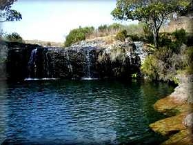
Photo: Willie Jacobs
|
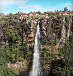
Sabie Falls
The Sabie Falls is situated on the R532 on the outskirts of
Sabie under the new bridge across the Sabie river. A short walk brings you to a
viewpoint where the waterfall plunges 73m down the Sabie Gorge. The foundations
of an old hydro-electric plant - from where Sabie obtained it's electric power
in 1907 - can still be seen at the bottom of the falls. Ample parking space -
also for tour busses. Negotiable by wheelchair with some assistance.
|

Photo: Chris du Plessis
|
Sabie Town
The town of Sabie is located 30km south of
Graskop on the R532. Although larger than Graskop, Sabie is still a
small Tourist & Forestry village on the banks of the pristine Sabie
River.
For more info on Sabie town, as well as
things to see and do in and around Sabie, visit the Sabie
Web Site.
|

Photo: Willie Jacobs
|
Bridal Veil Falls
The Bridal Veil Falls - resembling a bridal veil - is 6km from
Sabie town. Turn right at the Loggerhead Restaurant (first street in
Sabie) and follow the old Lydenburg tar road for 2km. Turn right at the GFP
Sawmill and follow the gravel (part tar) road across the Sabie river for
3km. A challenging 750m walk through an indigenous forest leads
to the 70m high waterfall. Public toilets are available. Not
wheelchair friendly. An entrance fee of R5/car is charged.
|

Photo: Chris du Plessis
|
Horse Shoe Falls
The aptly named Horseshoe Falls is in the shape of a horseshoe.
Turn right at the Loggerhead
Restaurant (first street in
Sabie) and follow the old Lydenburg tar road for 6.8 km before
turning left on the gravel road for a further 3.6 km. A nominal fee is
payable at the entrance gate. The gravel road can be very dusty when
dry and muddy when wet.
|

Photo: Chris du Plessis
|
Lone Creek Falls
One of the well known landmarks of the area.
Turn right at the Loggerhead
Restaurant (first street in
Sabie) and follow the old Lydenburg tar road for 9km.
A
nominal entrance fee is charged at the boom gate. A short (200m) walk
through an indigenous forest takes you to the bottom of the falls.
The 68m high waterfall is a declared
National Monument.
Toilet and picnic facilities are
available and the falls are easily accessible for tour busses.
|

Photo: SA Tourism
|
Graskop Gorge
The Graskop Gorge and Panorama Falls is only one
km out of town on the R535 towards Hazyview. The Panorama Falls is fed
by a
very small catchment area and is often just a trickle of water, but after heavy
rainstorms a number of separate falls can be seen spilling water into the
Gorge.
The Gorge offer some breathtaking views of the Lowveld below,
framed between the steep, forest-clad sides of the Gorge.
|
|
Silk Farm
Visit the Africa Silks Farm for an educational
guided tour on how silk is produced by the cultivated Bombyx mori,
better known as the Mulberry Silk Worm. They also process the wild silk of
our own, indigenous Mopani worm. The whole process, from eggs, worms,
cocoons, pupae, to the extraction of the silk is demonstrated. Situated 23
km east of Graskop, down Kowyn’s
Pass on the R533.
|

|
Coffee Farm
An educational guided tour of the Verster Coffee Estate
with an explanation of their planting, pruning and general cultivation
practices as well as a visit the plant where the coffee cherry is pulped
after picking, fermented to remove the sticky coating that remains after the
pulping, washing and drying, hulling and roasting processes.
Visitors are given the opportunity of tasting
coffees from other coffee growing areas and are shown how coffee experts
taste and evaluate the characteristics of coffee, similar to the way that
this is done with wine. Enjoy something light to eat in their coffee shop. Situated about 25km east of Graskop, down Kowyn’s
Pass on the R533.
|

|
Shangana Cultural
Village
The residents of the traditional villages of
Shangana invite guests to share in the way of life of the Shangaan people.
The picturesque villages are set in the shade of ancient trees in a reserve
of forest and grassland.
They offer daytime tours as well as an
Evening Festival when the history of the Shangaans is presented by a huge
cast of choristers and dancers before dinner is served inside the huts.
Prior bookings for the evening festival is essential. Located about
52km from Graskop on the R535 towards
Hazyview.
|

Photo: Chris du Plessis
|
Kruger National Park
The Kruger National Park, renowned for its Big 5, is located east of Graskop
along the R535 & R536 roads. The closest entry gate is Phabeni
Gate, only 55km from Graskop, making visits to Kruger a popular day trip
from Graskop.
|
 
Photos: Chris du Plessis
|
Bird Watching
The Graskop area is truly a birder's paradise
with three IBAs (Important Bird Areas) in the area. Not only is there a huge
variety of the more common bird species, but a number of globally and
nationally threatened species also occur in the area.
For more info about birding in the Graskop
area, please see our special Bird Watching page.
|

Photo: SA Tourism
|
Walks & Hikes
The hiking trails around Graskop range from easy
walks of a few hours, to grueling hikes over several days.
For more info about Walks & Hikes, see our Adventure page.
|

Photo: SA Tourism
|
|
For more about the wonders of Mother Nature,
see our special Natural
Heritage page
|
For more things to See & Do, visit
the website of nearby towns:
Sabie (www.sabie.co.za)
Pilgrim's Rest (www.pilgrims-rest.co.za)
|


